
The Constantly Evolving Guidebook
Sightseeing
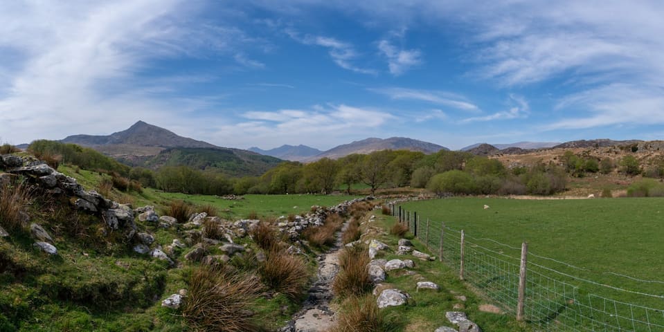
Llyn Geirionydd was reputedly the home of Taliesin and a stone monument to him stands by the lake’s north bank. He was a 6th-century Welsh bard and the earliest poet of the Welsh language whose work has survived. He was an inhabitant of the area, living on the shores of Llyn Geirionydd, and this is also where many say he is buried.
This is a walk you can take directly from the hut. It takes you up the Gwydir forest track and then down to and around the wonderful Llyn (Lake) Geirionydd. The lake is almost a mile long, covers an area of 45 acres and its deepest point is around 50 ft (15 m).
The walk is just over 6 miles (11 km) and you can do it comfortably in under 3 hours. You can of course take a picnic or just stop and admire the view. If you’re feeling adventurous you can also take your swimming gear and enjoy the amazing experience of a wild swim!
Leave our gate, pass the gate to Glyn Farm immediately outside and then take the next turn right up the farm track. Continue on and after a few hundred metres turn left at the big farm shed. The public pathway is directly ahead of you. Please remember to close all farm gates. Also please don’t run as you may startle any livestock that’s around.
Continue through the gate and you’ll climb up a narrow field. At the top, you’ll see a stile to the right of a metal gate. Climb over the stile (the gate is always locked) and take the path that goes left. This is the start of the forest track that you’ll be walking on.
Keep going straight on for a mile or so and you’ll pass a lake (Llyn Bychan) on your left.
Go past the lake and at the brow of the track you’ll see a path going to the left. Take this path and you’ll cross a cattle grid.
Keep on this track for a mile or so and you’ll come to another cattle grid. Turn right here and follow the track all the way down to the Llyn.
You can either pick a spot and admire the beauty. Then you just retrace your steps back to the hut.
But if you do this you’re missing the best bits! Follow the track around the Llyn in an anti-clockwise direction. Keeping the Llyn on your left as you go to the end.
When you get here, go through the gate across the bottom of the Llyn. This is a wonderful place to stop and admire the view and perhaps take some photos.
Look out for the Taliesin monument with a cross on the top - this will be on a hill on your right. There’s also a stone building on your left.
Keep left and you’ll see a white house tucked away on your right. Go through the gate on the lakeshore and follow this path around.
Be careful though because this can get wet. Also, look out for rocks and protruding tree roots which can trip you up or cause a nasty sprain or worse! Just keep your eyes peeled, take your time and you’ll be fine.
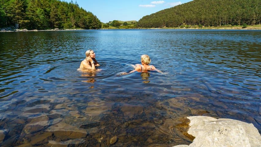
When you get to the end of this first track, you’ll come across a small shingle beach. This is a great place to rest and also to swim from.
Then you climb gently up through the trees. Again keep your eyes open and be careful with tree roots. If they are wet they are slippery and you don’t really want to trip and take a swim fully clothed!
When you get to the top of this rocky outcrop, come down the other side and follow the track with the Llyn on your left. Keep going ahead and you’ll rejoin the path you originally came down to when you first saw the Llyn.
Then just retrace your steps back upon the track, across the cattle grid on your left, and back towards the hut.
This is a wonderful walk and if the weather is good it rivals anywhere in the world. The sheer beauty of the landscape is simply breathtaking.
27 preporuka/e lokalaca
Llyn Geirionydd
Llyn Geirionydd was reputedly the home of Taliesin and a stone monument to him stands by the lake’s north bank. He was a 6th-century Welsh bard and the earliest poet of the Welsh language whose work has survived. He was an inhabitant of the area, living on the shores of Llyn Geirionydd, and this is also where many say he is buried.
This is a walk you can take directly from the hut. It takes you up the Gwydir forest track and then down to and around the wonderful Llyn (Lake) Geirionydd. The lake is almost a mile long, covers an area of 45 acres and its deepest point is around 50 ft (15 m).
The walk is just over 6 miles (11 km) and you can do it comfortably in under 3 hours. You can of course take a picnic or just stop and admire the view. If you’re feeling adventurous you can also take your swimming gear and enjoy the amazing experience of a wild swim!
Leave our gate, pass the gate to Glyn Farm immediately outside and then take the next turn right up the farm track. Continue on and after a few hundred metres turn left at the big farm shed. The public pathway is directly ahead of you. Please remember to close all farm gates. Also please don’t run as you may startle any livestock that’s around.
Continue through the gate and you’ll climb up a narrow field. At the top, you’ll see a stile to the right of a metal gate. Climb over the stile (the gate is always locked) and take the path that goes left. This is the start of the forest track that you’ll be walking on.
Keep going straight on for a mile or so and you’ll pass a lake (Llyn Bychan) on your left.
Go past the lake and at the brow of the track you’ll see a path going to the left. Take this path and you’ll cross a cattle grid.
Keep on this track for a mile or so and you’ll come to another cattle grid. Turn right here and follow the track all the way down to the Llyn.
You can either pick a spot and admire the beauty. Then you just retrace your steps back to the hut.
But if you do this you’re missing the best bits! Follow the track around the Llyn in an anti-clockwise direction. Keeping the Llyn on your left as you go to the end.
When you get here, go through the gate across the bottom of the Llyn. This is a wonderful place to stop and admire the view and perhaps take some photos.
Look out for the Taliesin monument with a cross on the top - this will be on a hill on your right. There’s also a stone building on your left.
Keep left and you’ll see a white house tucked away on your right. Go through the gate on the lakeshore and follow this path around.
Be careful though because this can get wet. Also, look out for rocks and protruding tree roots which can trip you up or cause a nasty sprain or worse! Just keep your eyes peeled, take your time and you’ll be fine.
When you get to the end of this first track, you’ll come across a small shingle beach. This is a great place to rest and also to swim from.
Then you climb gently up through the trees. Again keep your eyes open and be careful with tree roots. If they are wet they are slippery and you don’t really want to trip and take a swim fully clothed!
When you get to the top of this rocky outcrop, come down the other side and follow the track with the Llyn on your left. Keep going ahead and you’ll rejoin the path you originally came down to when you first saw the Llyn.
Then just retrace your steps back upon the track, across the cattle grid on your left, and back towards the hut.
This is a wonderful walk and if the weather is good it rivals anywhere in the world. The sheer beauty of the landscape is simply breathtaking.
Cwm Idwal is a very special place. The spectacular scenery comprises high crags, screes, moraines, and rounded rocks, with a lake on its floor (Llyn Idwal). The folds and faults are the direct results of the tumultuous forces that pushed up these mountains 450 million years ago.
The more recent Ice Age sculpted and gouged their cliffs and ridges, as well as the great amphitheater of Cwm Idwal itself. It’s one of the best examples of a glacial valley in Wales, so it attracts geologists, mountaineers, groups of students, and botanists. It’s also an accessible and popular visitor destination, so it can get busy.
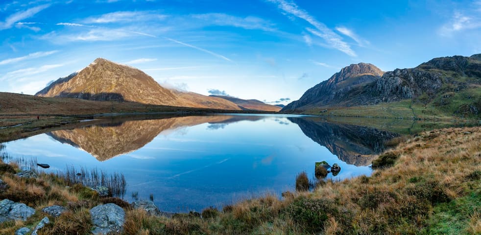
Llyn (lake) Idwal is a great natural amphitheater that can act as a gigantic mirror. If you get lucky you can see perfect reflections like this of Pen yr Ole Wen on the left and the mighty Tryfan on the right.
Llyn Idwal is approximately 800m long by 300m wide and it covers 28 acres. It is named after Prince Idwal Foel, a grandson of Rhodri Mawr, one of the ancient Kings of Wales. Legend states that the prince was murdered by being drowned in the lake. In fact Idwal Foel died in battle against the Saxons in 942 and he was cremated beside the lake, as was the burial custom for Celtic nobility.
Llyn Idwal is easily accessible on foot via a 900-metre long stone-paved path from Ogwen Cottage on the main A5 road. Another path encircles the lake. Two paths lead from opposite sides of the lake to the top of the ridge close to the Twll Du (Devil's Kitchen), but these paths become rather steep in places. They lead to Glyder Fach and Glyder Fawr.
There is a small pebble beach at the northwest edge of Llyn Idwal from which you see hardy and brave swimmers take the plunge. The water is crystal clear and gorgeous. But it’s a mountain lake so it’s also cold. If you are going to swim, please be fully prepared and don’t take any unnecessary risks.
20 preporuka/e lokalaca
Cwm Idwal
Cwm Idwal is a very special place. The spectacular scenery comprises high crags, screes, moraines, and rounded rocks, with a lake on its floor (Llyn Idwal). The folds and faults are the direct results of the tumultuous forces that pushed up these mountains 450 million years ago.
The more recent Ice Age sculpted and gouged their cliffs and ridges, as well as the great amphitheater of Cwm Idwal itself. It’s one of the best examples of a glacial valley in Wales, so it attracts geologists, mountaineers, groups of students, and botanists. It’s also an accessible and popular visitor destination, so it can get busy.
Llyn (lake) Idwal is a great natural amphitheater that can act as a gigantic mirror. If you get lucky you can see perfect reflections like this of Pen yr Ole Wen on the left and the mighty Tryfan on the right.
Llyn Idwal is approximately 800m long by 300m wide and it covers 28 acres. It is named after Prince Idwal Foel, a grandson of Rhodri Mawr, one of the ancient Kings of Wales. Legend states that the prince was murdered by being drowned in the lake. In fact Idwal Foel died in battle against the Saxons in 942 and he was cremated beside the lake, as was the burial custom for Celtic nobility.
Llyn Idwal is easily accessible on foot via a 900-metre long stone-paved path from Ogwen Cottage on the main A5 road. Another path encircles the lake. Two paths lead from opposite sides of the lake to the top of the ridge close to the Twll Du (Devil's Kitchen), but these paths become rather steep in places. They lead to Glyder Fach and Glyder Fawr.
There is a small pebble beach at the northwest edge of Llyn Idwal from which you see hardy and brave swimmers take the plunge. The water is crystal clear and gorgeous. But it’s a mountain lake so it’s also cold. If you are going to swim, please be fully prepared and don’t take any unnecessary risks.
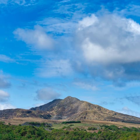
This is our local mountain and we can see it from our cottage in Snowdonia. It’s called Moel Siabod, which is Welsh for ‘the shapely hill’. It sits above Capel Curig and at 872 metres (2,861 ft), it is the highest peak in the Moelwynion range. On a clear day on the summit, you can see 13 of the 14 highest peaks in Wales.
I take so many photographs of Siabod, mainly because it’s so accessible to me. And it changes according to the time of year and day. The quality of light can make even the finest details stand out. I often feel that I could just reach out and touch the ridges that I know so well.
But then it occurred to me that Siabod was more than a set of ridges and rocks. It has a character and profile that is so distinct and recognisable with twin summit peaks.
One early summer morning I sat and looked at the slow-motion drama unfolding in front of me as these huge ethereal structures moved slowly and gracefully across the sky. There was no sound other than occasional birdsong. I was lost in my thoughts about nothing in particular, almost a meditative state. The effect was calming, mesmeric, and beautiful.
24 preporuka/e lokalaca
Moel Siabod
This is our local mountain and we can see it from our cottage in Snowdonia. It’s called Moel Siabod, which is Welsh for ‘the shapely hill’. It sits above Capel Curig and at 872 metres (2,861 ft), it is the highest peak in the Moelwynion range. On a clear day on the summit, you can see 13 of the 14 highest peaks in Wales.
I take so many photographs of Siabod, mainly because it’s so accessible to me. And it changes according to the time of year and day. The quality of light can make even the finest details stand out. I often feel that I could just reach out and touch the ridges that I know so well.
But then it occurred to me that Siabod was more than a set of ridges and rocks. It has a character and profile that is so distinct and recognisable with twin summit peaks.
One early summer morning I sat and looked at the slow-motion drama unfolding in front of me as these huge ethereal structures moved slowly and gracefully across the sky. There was no sound other than occasional birdsong. I was lost in my thoughts about nothing in particular, almost a meditative state. The effect was calming, mesmeric, and beautiful.
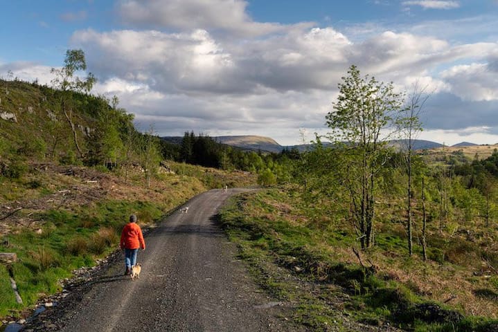
This walk is not strictly in Capel Curig. It's around the forest track at the back of Glyn Hut.
Leave our gate, pass the gate to Glyn Farm immediately outside and then take the next turn right up the farm track. Continue on and after a few hundred metres turn left at the big farm shed. The public pathway is directly ahead of you. Please remember to close all farm gates. Also please don’t run as you may startle any livestock that’s around.
Continue through the gate and you’ll climb up a narrow field. At the top you’ll see a stile to the right of a metal gate. Climb over the stile (the gate is always locked) and take the path that goes left. This is the start of the forest track that you’ll be walking on.
Keep going straight on for a mile or so and you’ll pass a lake (Llyn Bychan) on your left. If you’re lucky you’ll get great reflections here and it’s worth walking to the shore at the far end and siting on the large rocks that are in the water. This is such a beautiful and peaceful place where you’ll usually hear nothing other than the sound of birds.
Go past the lake and at the brow of the track you’ll see a path going to the left. Don’t take that for this walk, instead keep right. Just stay on the path and as it descends back on itself, you’ll eventually go past an old quarry on your right. Here you will get a great view of Moel Siabod (the mountain you see from the hut) poking through the forest ahead of you.
Eventually you’ll come to a junction and turn left. You have now completed a circular path and will head back down towards the hut. As you descend, there’s an option to see another lake. Take the first available left up a path and go underneath (or around) a metal barrier. Go up that path and you’ll come to the lake where we get our water from. It’s called Llyn (Lake) Goddionduon. It lies at a height of 794 ft (242 m) above sea level and covers an area of 10 acres (40,000 m2). It is unusual in that it is totally natural, whereas nearly all of the other lakes in the forest have been partially or totally constructed as water sources for the mines which were scattered throughout the Forest.
From here you’ll also get another great view of Siabod in the distance. When you’re ready, retrace your steps and join the path back towards the hut.
14 preporuka/e lokalaca
Capel Curig
This walk is not strictly in Capel Curig. It's around the forest track at the back of Glyn Hut.
Leave our gate, pass the gate to Glyn Farm immediately outside and then take the next turn right up the farm track. Continue on and after a few hundred metres turn left at the big farm shed. The public pathway is directly ahead of you. Please remember to close all farm gates. Also please don’t run as you may startle any livestock that’s around.
Continue through the gate and you’ll climb up a narrow field. At the top you’ll see a stile to the right of a metal gate. Climb over the stile (the gate is always locked) and take the path that goes left. This is the start of the forest track that you’ll be walking on.
Keep going straight on for a mile or so and you’ll pass a lake (Llyn Bychan) on your left. If you’re lucky you’ll get great reflections here and it’s worth walking to the shore at the far end and siting on the large rocks that are in the water. This is such a beautiful and peaceful place where you’ll usually hear nothing other than the sound of birds.
Go past the lake and at the brow of the track you’ll see a path going to the left. Don’t take that for this walk, instead keep right. Just stay on the path and as it descends back on itself, you’ll eventually go past an old quarry on your right. Here you will get a great view of Moel Siabod (the mountain you see from the hut) poking through the forest ahead of you.
Eventually you’ll come to a junction and turn left. You have now completed a circular path and will head back down towards the hut. As you descend, there’s an option to see another lake. Take the first available left up a path and go underneath (or around) a metal barrier. Go up that path and you’ll come to the lake where we get our water from. It’s called Llyn (Lake) Goddionduon. It lies at a height of 794 ft (242 m) above sea level and covers an area of 10 acres (40,000 m2). It is unusual in that it is totally natural, whereas nearly all of the other lakes in the forest have been partially or totally constructed as water sources for the mines which were scattered throughout the Forest.
From here you’ll also get another great view of Siabod in the distance. When you’re ready, retrace your steps and join the path back towards the hut.
This is another walk you can do from the hut. Unless you know about it, you probably wouldn't find it - that's why we say it's our 'secret walk'!
This can either be a circular walk back along the A5, or you can retrace your steps and stick to the forest. The whole circular walk is around 5 miles. There are inclines but if you’re reasonably fit and mobile it should be no problem.
Leave our gate, pass the gate to Glyn Farm immediately outside and then take the next turn right up the farm track. Continue on and after a few hundred metres turn left at the big farm shed. The public pathway is directly ahead of you. Please remember to close all farm gates. Also please don’t run as you may startle any livestock that’s around.
Continue through the gate and you’ll climb up a narrow field. At the top, you’ll see a stile to the right of a metal gate. Climb over the stile (the gate is always locked) and take the path that goes left. This is the start of the forest track that you’ll be walking on.
After around half a mile you’ll see the path bend to your left. This is the first turning you’ll come to. Take this and you’ll drop down and then start to climb towards a viewing point where you will get a gorgeous view over the valley.
Now head up the track and when it levels off you’ll see Siabod and Snowdon ahead of you. It’s quite a sight and you’ll probably want to stop and take it all in. Grab a drink maybe and shoot some photos as a keepsake. This can be spectacular but there’s more to come!
From here, you can turn back and retrace your steps. When you get back to the main track (the one you turned left from) you could either turn right back to the hut. Or you could turn left and continue up towards Llyn Bychan. (See the post ‘A circular walk through the Gwydir forest’ for details).
If you decide to continue, go through 2 metal gates (please close them after you). You’ll cross a small stream and then you’ll come to a stile. Go over this and you’ll see the Crimpiau mountain range on your right, Siabod on your left, and the Snowdon Horseshoe and the Carneddau ahead.
Follow the path down and veer left. You’ll pass a clump of trees on your right and you’ll see Siabod slightly to your left. You’ll then see another stile ahead. Cross this and keep left at the waymarker. Go down a dip in the ground and cross yet another stile. Be careful here as the ground and rocks are uneven. When it’s wet it’s also slippery.
You are now on another track. Keep going ahead and follow it over a few streams and then take the second right-hand fork where you’ll descend and see yet another stile and a metal gate. Cross this and you’ll see a house soon on your left and another metal gate in front of you. Go through this and you’ll now be on the road. You can now turn left and follow it for just over a mile to return to the hut. You’ll also pass a pub called the Tyn-y-coed and if it’s one you can enjoy a well-deserved snack and drink!
14 preporuka/e lokalaca
Capel Curig
This is another walk you can do from the hut. Unless you know about it, you probably wouldn't find it - that's why we say it's our 'secret walk'!
This can either be a circular walk back along the A5, or you can retrace your steps and stick to the forest. The whole circular walk is around 5 miles. There are inclines but if you’re reasonably fit and mobile it should be no problem.
Leave our gate, pass the gate to Glyn Farm immediately outside and then take the next turn right up the farm track. Continue on and after a few hundred metres turn left at the big farm shed. The public pathway is directly ahead of you. Please remember to close all farm gates. Also please don’t run as you may startle any livestock that’s around.
Continue through the gate and you’ll climb up a narrow field. At the top, you’ll see a stile to the right of a metal gate. Climb over the stile (the gate is always locked) and take the path that goes left. This is the start of the forest track that you’ll be walking on.
After around half a mile you’ll see the path bend to your left. This is the first turning you’ll come to. Take this and you’ll drop down and then start to climb towards a viewing point where you will get a gorgeous view over the valley.
Now head up the track and when it levels off you’ll see Siabod and Snowdon ahead of you. It’s quite a sight and you’ll probably want to stop and take it all in. Grab a drink maybe and shoot some photos as a keepsake. This can be spectacular but there’s more to come!
From here, you can turn back and retrace your steps. When you get back to the main track (the one you turned left from) you could either turn right back to the hut. Or you could turn left and continue up towards Llyn Bychan. (See the post ‘A circular walk through the Gwydir forest’ for details).
If you decide to continue, go through 2 metal gates (please close them after you). You’ll cross a small stream and then you’ll come to a stile. Go over this and you’ll see the Crimpiau mountain range on your right, Siabod on your left, and the Snowdon Horseshoe and the Carneddau ahead.
Follow the path down and veer left. You’ll pass a clump of trees on your right and you’ll see Siabod slightly to your left. You’ll then see another stile ahead. Cross this and keep left at the waymarker. Go down a dip in the ground and cross yet another stile. Be careful here as the ground and rocks are uneven. When it’s wet it’s also slippery.
You are now on another track. Keep going ahead and follow it over a few streams and then take the second right-hand fork where you’ll descend and see yet another stile and a metal gate. Cross this and you’ll see a house soon on your left and another metal gate in front of you. Go through this and you’ll now be on the road. You can now turn left and follow it for just over a mile to return to the hut. You’ll also pass a pub called the Tyn-y-coed and if it’s one you can enjoy a well-deserved snack and drink!
Portmeirion is best in good weather because the colourful buildings come alive. And it's easier to room around the gardens and visit the coast.
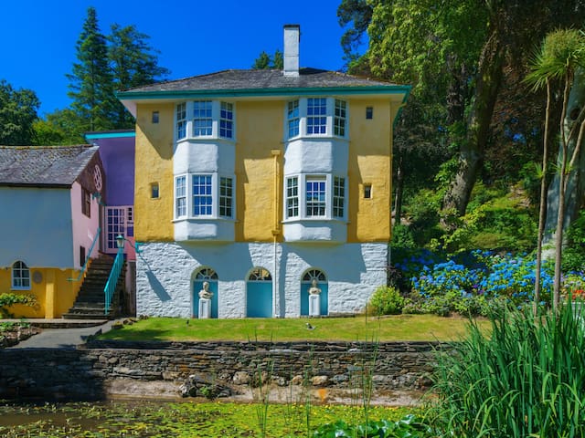
Portmeirion North Wales
Portmeirion is best in good weather because the colourful buildings come alive. And it's easier to room around the gardens and visit the coast.